C.K's Flight Log 2003-2004
Go to 2005 2006 2007 2008 2009 2010 2011 2012 2013 2014
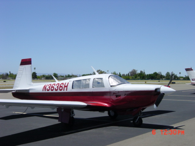
Places I've been, how I got there, comments on airports and navaids. I fly out of Reid-Hillview airport and I'm parked at Hangar J-4. Stop by and say "Hey"! Latest flights first : Note: All flights since May 2004 are in Mooney M20K 231 N3636H unless otherwise indicated. Further note: if you see an na after an approach count, that stands for not actual's, meaning I shot the approach in VFR conditions without a hood.
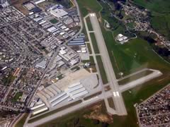
21 December 2004 RHV SCK O27 MOD Time: 3.0 Landings: 1 Approaches: 8
Flew out to Stockton alone, planned to meet Don there, do our air work, then
leave the airplane at Top Gun aviation for some work. Very bumpy coming out
of Reid Hillview going over the Calveras Pass (fortunately there were PiReps
on DUATS so I was prepared). One moderate jolt, most light. Then at about 3500
it just stopped. On out to Stockton VFR into 29L, nice landing. Taxied over
to Top Gun and got set up for the work (see maint
log) . Don flew in, got back into my airplane and did 8 approached. Started
with two ILS into Stockton, went very smoothly. Localizer was pretty much dead
on, still need some work on power settings for glideslope. Then GPS, VOR. Then
over to Oakdale for the GPS approach there, went very nicely. Flew missed to
the correct intersection and flew the hold, forgot to tell the controller when
I entered the hold. Then over to Modesto for GPS & VOR/DME, both were OK.
Back to Stockton, ILS for full stop. At decision height I wanted to land, Don
coaxed me through staying on glide to the runway, that's what it's there for.
Nice landing, over to Top Gun. During turbo cool-down left mag ran very rough,
400 RPM drop. Glad it's staying there to get worked on!
17 December 2004 RHV SCK TCY LVK Time: 3.2 Landings: 1 Approaches: 8
Bright sunny day, some haze. So time to fly around under the
hood.
Out to Stockton, did the GPS approach. Then ILS approaches, first I
fell off altitude control at the end, then right down the pike,
close
to needles centered the whole way down. Not perfect, but good. Over to Tracey
to do a few GPS and VOR approaches in. With the sun and the haze, even though
there were no clouds, it was a VFR day that you needed an IFR rating to fly
in. VOR
approaches were OK, Don failed the attitude indicator & the heading indicator
on the first one, and I was conflicting my reactions by splitting my attention
between the Garmin 530 and the CDI for the 2nd radio for nav. I need to pick
one and track it. 2nd one was better. Back to the hold at the Tracey VOR and
on tot he Livermore ILS. Not so good, I delayed reacting to the glideslope.
Part of the problem, which I'm sure some folks in more desolate areas would
be kinda irked with me about, is that our instrument airports are so close
together up here in NorCal, you just climb up out of the missed on one approach
and you're almost already tracking the localizer on the next. Back to RHV.
12 December 2004 RHV SCK Time: 1.9 Landings: 1 Approaches: 3
Nice cloudy day. Out to Stockton, didn't have time to do a
lot so just one GPS and one ILS into Stockton, then the GPS to RHV. Don
failed the attitude indicator on the way out. He also pulled the circuit breaker
on the turn coordinator. Easier to fly straight-and-level with those two failed
than I thought it would be Autopilot GPS approach with the Garmin 530 was a
non-event. The only challenge is insuring you hit the step-downs right with
the autopilot up/down buttons. ILS was not quite as good, I was probably 200
ft. right on breakout. Probably could have made the landing, but sloppy.
Interesting thing was ATC being super-busy. Quite a few folks asking for popup IFR clearances, and the Santa Clara valley was hopping because the wind was from the south, so San Jose departures were to the south, which clogs up flow into the valley. ATC did a great job, but you could hear it in their voices that it was a stressful afternoon.
7 December 2004 RHV SCK TCY LVK Time: 4.5 Landings: 3
Approaches:
12
Starting & scheduling problems hopefully behind us. lets
go IFR training. Airplane did start on the first spin, but still harder to
start
than I'd like. IFR climbout to Stockton. Weather somewhat cloudy, but very
gentle, passing through the clouds with hardly a bump. One GPS then 3 ILS
approaches into Stockton, then we landed. Landed with a quartering tailwind,
good practice
and good that it was an 8,000 ft runway. Though actually I was down in 4,000.
Taxied over to Top Gun aviation, met Tom Rauch, had some good talk and a
nice break.
Started
back
up, did
the
GPS
then 3
VOR approaches into Stockton. On the missed, flew over to Tracey to do the
VOR there. Entering the hold at Tracey, ATC let us know that we would have
to spin in the hold for a while while other traffic passed. Great! Not just
a procedure turn, but a real hold! VOR into Tracey, missed, another VOR approach,
miss and hit the hold, set up for the ILS into Livermore, flew it in to about
1,000 ft then circle to land the other way. Taxied to the end, then back
up and GPS approach into Reid-Hillview.
That's a lot of flying. 4.5 hours in the air, 12 approaches. Not a bad days work! Only one minute where I let the airplane get to the squirrel point, recovered it. Only one "N3636H, maintain 3,000!" call from ATC. One bitter controller at Stockton who scolded me for not checking in when I had just that second been cleared to switch frequencies from Approach. Just said "Sorry" in reply. Heard one jerk on the airwaves, ATC asked him twice what altitude he wanted, both times he said nastily "I filed for 17,000!". Well, dude, if you filed for 17,000, why not just say "Requesting 17,000 please". Sheesh. Needle following was much better today, I still need work on altitude. Once I get there and get trimmed things are great, it's just taking too long to get there.
26 November 2004: RHV Time
.8 Landings 1
Just wanted to fly a little.
20-21 November 2004: RHV Paso
Robles RHV
Time 2 landing 2
Down to Paso Robles for a weekend visit to Justin Winery. Took
off at about 10 AM, forecast was that Paso Robles would be clear at 10. Got
about 40 miles out, and heard on IFR takeoff from Paso, and the ASOS was
reporting 100 ft ceiling and 1 mile vis. ABout 8 miles out we told Oak Center
that we were diverting to San Luis Obispo (which was 10/20). Got right over
PRB and looked down, and the airport was VFR. Don't know what's wrong with
their ceiling reporter,there was no ceiling. Landed on rwy 1, parked.
Back out Sunday morning, little windy on the field. Weather
briefer had told us of wind and light turb along the route north, but completely
clear. Not a bad flight back, the bumps down by PRB were very mild, and the
wind was not directly on the nose so we kept 145-155 knots groundspeed. Kept
the airplane at 8,500 since the trip was so short. Dropped ito the Silicon
valley, and was surprised at the turbulence. We were getting buffeted around
at 4,000 ft. more than I've ever felt in 3 years flying the Valley. Dropped
down to RHV, bumps smoothed out below 2,000, nice landing with a 15 knot
wind right on the nose cushioning us on to the ground.
BTW, easy pickup of VFR traffic advisories on both flights.
13 November 2004: RHV Stockton RHV
Time 2.9 landing 1
Back to IFR training after two weeks of airplane in the shop.
Nice cloudy day. Out to Stockton, shot the GPS and VOR approaches. 2.9 on
the clock, and about 1.5 of that was actual instrument, which was neat. Still
not
deliberate enough on course and altitude corrections, but it got better
as
we went on. Back to RHV and the GPS approach into RHV. 7 approaches total,
a good workout.
12 November 2004: RHV Time .4 landing 2
Airplane out of maintenance, two circuits of the pattern to
make sure everything is OK. It is.
30 October 2004: RHV UKI RHV Time 2.2 landing 2
Wanted to fly a little without being under the hood. Planned to go up to Mendocino. since it might be clear. Nice day at RHV, hard start on the engine (going into the shop Monday to fix that). Up and away, up to 8.5k after passing the SFO class B. Out to the coast after Sonoma airport. Got up to Point Arena, and was clear that Mendocino was not going to be possible. Called FlightWatch to give them a pirep and let them know that Mendo was closed (they don't have any coastal weather reporting facilities nearby so pireps help a lot), they said Thanks and asked what my new destination was. Uuuuh, I dunno, I just found out Mendocino was closed. Decided fast on Ukiah, and flew 10 minutes back inland to land at Ukaih (NRST-direct, follow the line, GPS is so cool) because I hadda go to the restroom. Nice landing. Of course, on a 5000x1500 runway it's hard not to make a nice landing. Wandered around thinking we could get something to eat, but the diner across the street was closed. So back into the airplane and up. Up to 7.5k, picked up flight following and on into the bay area. Nice tailwind, we were making, at 7.5k, 196 knots ground speed, which is ripping right along. Since I had ATC tracking, I stayed up at 5.5k over Concord and down to Livermore. I usually drop down to 3.5, since the base of the Class B is 6k, but with ATC I am comfortable staying 500 feet clear at 5.5, And it kept us in the wind, we were still making 170 knots gs down the 680 freeway. In to the RHV area, and things were busy The tower was handling a lot of airplanes, and there were more than usual folks who were being stupid, not following good radio procedure. At one point he was talking to two cessnas coming up from the south, and one censsa asked "Cessna XXX, was that for me" and the tower said "Well, since you're the only one of the two that is responding, I'll talk to you". We were coming in from the north, which always means looking out for traffic taking off. Fortunately we were watching, and I did a left 360 to avoid a Cherokee taking off. Told the tower I was turning, and he apologized, the Cherokee had waited too long after getting his takeoff clearance. Then down the rest of the pattern, and a Baron was close in for a straight in for the same runway, and the tower asked if I could tighten my turn to base, then he modified that to say "Just teardrop in to the runway". Heck, Mooneys built for that, make the turn, pop the speed brakes, drop right down and stuck a very pretty short field landing and got off the runway at the 2nd taxiway.
28 October 2004: RHV SNS
RHV Time 1.9 landing 1
IFR training. Approaches into Salinas tonight for the first time. Went well
for a first time. Approach number one was a behind the curve a mile approach,
but but after the first experience of doing all the bits it got better. Practice
will work this out, there were no barriers to knowing what to do, just time
to actually do all the parts.
23 October 2004: RHV ECA
RHV Time 2.6landing 1
IFR training, dang, been 11 days since I flew, much less flew
under the hood. Filed an IFR plan out to Stockton, the gentleman at the FSS
was very chatty, and very grumpy at you lazy guys at Stockton for not having
your ASOS complete, he's mad at you. Engine hard to start, too, of course after
sitting for more than a week, taxi out, get clearance, then sit between the
runways waiting for release. It was an "Everybody south" day, so
San Jose was taking off southward as well as RHV, that adds delay since I basically
have to fly across their departure path to cross over the SJC VOR for the SUNOL
departure. Waited about 8 minutes for release, then up and out. Real IMC, lots
of calm, collected, stratus clouds to fly through out to Stockton, which was
nice, I could lift the hood and fly "real" IFR for much of the transit
time. No bumps, not much wind, this was a very very slow moving front coming
through.
Out near Stockton, Don asks for some space around the Manteca VOR. We get 5
NM @ 5,000 to play around in. An hour and a half of holding. Teardrop. Parallel,
Direct, etc. etc., did a heck of a lot of holding. Not bad, now that I've done
it I need to go back and re-read it and integrate what I read with what I did.
Back to RHV, fly the GPS 31 approach for real this time,. Pretty much fun.
Good landing for speed and flare, slightly sideways on touchdown.
Oh, and by the way: When I first bought 3636H I debated keeping
the KNS-80 and Loran vs. upgrading to the GNS 530. Hooo boy, am I sure glad
I had the 530 installed! The awareness the 530 gives you in IFR conditions
cannot be beat (well, it can be beat with a bigger screen full color system,
but you know what I mean).
12
October 2004: RHV Time 2.0 landing 1
2nd IFR training flight. Up (hood on at 1,000) and over to
Salinas. VOR intercepts, DME arcs, and two procedure turns. Did OK, I need
to work a little more on my visualization of the task. Once we're into it,
then flying the task is fine (except for some sloppy altitude at times),
but my internal pre-visualization needs to be better. I have some ideas.
Flight was predominately night, so no peeking. Though I'm not really tempted
to peek under the hood, peeking doesn't make your altitude any better, now
does it?
Back to RHV, ran the GPS approach for the first time (Figure I'll be doin'
that a lot). Then onto the ground, not a great landing, but not a killer.
1.9 under the hood.
10 October 2004: RHV Time 1.9 landing 1
OK, so I lied up there, I will list my training flights. Took
my first IFR training flight (contact me privately if you want to know my
instructors name, I don't want him spammed unnecessarily). Of course, the
first IFR flight just had
to be on a perfectly beautiful CAVU day! Spent 1.7 under the hood over the ocean
(dammit, it was pretty out there when I peeked) doing airwork to hone my instrument
scan and interpretation. This was the first time I had spent any time in the
Mooney
under the hood, so it was a good calibration of feel for the instruments. Obviously,
1.7 hours meant a lot of work, and I felt very comfortable. Didn't do perfectly,
of course, but better than I thought I would for the first time under the hood,
and got a good feel for what I consider to be two important airplane feel
issues; what a standard rate turn feels like to set, and better throttle use.
I was too slow applying power at first, got better at it. ANd having an HSI with
a couple flux gate compass sure takes the "set DG to compass" anxiety
out of things.
2-3 October 2004: RHV -
PRB - RHV To:1.1, 1 landing Return 1.4,
2 landings Flight
down completely uneventful, just an hour's hop down the101. Return, we left
knowing that San Jose and RHV were overcast at 1,300, but might make the
forecast, clearing by the time we got there.
Got to Hollister, and could see solid undercast ahead, so we went over to
the inland valley and flew on up to a VFR Livermore for lunch. An hour later,
clouds broken up over RHV, short hop back.
29 September 2004: RHV
18-19 September 2004:RHV- -VGT - RHV 11 September 2004:RHV- -RHV Just flyin around. Little high on flare (as usual), but fine
landing. Hmmm, anything else? Nope.
4-6 September 2004:RHV- KBUR -RHV Very simple flight down, turn over the VORs and in. Over Gorman
I told the controller that I was beginning my VFR decent, and he said "OK,
Cleared to descend, cleared for straight in RWY 15, cleared to land, stay
about 3,000, keep your speed up"!!. Hah, still at 13,5000 and I'm cleared
to land, pretty much A-OK. I wanted to stay
a little high over the foothills because there had been some turbulence reports.
I was about 115 miles and passing through 10,000 when the controller asked
if I was going to actually be able to make the approach. I replied "36H
will make the approach, deploying speed brakes now". Airliner power
decent with the spoiler up, 1600-2000 FPM and 180 knots, I love this airplane.
At 3,000 4 miles out, brought the brakes in, switched to tower, cleared to
land 15. Stayed at 150 knots until 1.5 miles out, bumped the speed brakes
out again, dropped throttle. Over the blast fence brought the speed brakes
in, nice 80 knots, settled gently down on the 150 wide runway, nice landing.
Parked at Mercury Air Center. OK service, nothing to write
home about. They didn't charge my O2 bottle like I had asked, fortunately
I had enough to get us home.
Took off Monday, Golden State departure north. LA Center could
not provide flight following. I climbed to 12,500 and just punched the GPS
direct to RHV and flew in a straight line for an hour and a half. Started
descending south end of the valley, real power decent this time, 600 FPM
and ground speed of 201 knots (still 20 knots shy of the yellow line on indicated
airspeed). Landed a little long, but fine, parked, home.
31 August 2004:RHV- RHV Been a while since I had a long flight, so went up and around.
Out to Frazier lake, then into the inland valley. Steep turns left & right,
some slow flight, then back into the silicon valley and to RHV. Nice landing.
I had NO, zero, flaps on this landing and it seemed to settle much more comfortably
and easily. 29 August 2004:Concord-RHVCCR- RHV 16 August 2004:Reid- Concord RHV - CCR 14 August 2004:Reid- Concord RHV -
CCR . 10 August 2004: RHV 8 August 2004: RHV-Oakdale RHV-O27 25 July 2004: RHV - O61 Out
to Cameron Park 23
July 2004: RHV RHV
7 July 2004: RHV RHV .
Wanted to fly this evening. Did. Went over Hollister, did some steep turns, did
some different decent's. Then nailed two landings to replace the one stinky
one I had on Monday.
4-5 July 2004: Reid Hillview - Santa Ana/John Wayne
Airport - RHV
Weather: Ceiling 12,000, 17, Duration:2.4
out 2.2 return Landings:2 Aircraft:Mooney
M20K 231 N3636H
Down to Santa Ana for the 4th for a resort day and visit Karen's
daughter. 25 June 2004: RHV RHV Flying. That's it.
20 June 2004: RHV-South Lake Tahoe RHV-TVL Didn't have the straight in for 18, right traffic for 36. And
boy howdy, that was the absolute best landing I've had in any airplane, she
just settled right down on the runway with the stall horn chirping the last
little bit. In to town in a taxi. Won't do that again, the taxi ride in was
$25, back to the airport was $20, would have been better to rent a car. Played
poker at Harvey's (lost $11) for a few hours while Karen shopped, then back
to the airport. Density altitude was 8,400. Engine of course was fine, took
the active and had a very nice climb out, using just a little more runway
than I do at sea level. And 8,000 feet of wide concrete sure is nice to have.
Back to Reid Hillview, another nice landing. Only irksome thing
is the taxi from the runway to my parking spot is really short, so I have
to sit there with the engine running for 4 minutes more to cool the turbo.
19 June 2004: RHV-Oakdale RHV-O27 16 June 2004: RHV-Oakdale RHV-O27 More solo hours to log getting used to the airplane. Out to
Oakdale, then down to Los Banos, across the mountains, then back to RHV.
Stinky sky conditions, it might have said 10 miles, but the smog was so thick
you could not see 10. Out to Oakdale, and damn
this airplane goes fast. Even keeping it slow and low (7,500) to burn about 10
gph I nearly cut the time on a reasonably short trip like this in half. Landed,
a little bit of a struggle because of the haze/smog and the low sun. Back up,
complete the circuit. Or not. Passing over Los Banos I could see that the south
half of the Santa Clara valley was fogged in. Didn't want to fly over solid fog
if I could help it, so instead of crossing by Frazier Lake I flew north so I
could cross over at South County (Q99).
The into RHV. But damn, 7 miles out and I can barely see the airfield, and the
sun is making it worse. Was way to high on approach, and went around. Second
time 'round everything was fine and landed. Flight, again, not flat out, 65-70%
power, cut a full hour of Piper time for the same route.
14 June 2004: RHV Gotta get my 10 solo so I can carry Pax, more hours. 4.1 down.....
12 June 2004: RHV - Lampson Field- Ukiah-Willits-Shelter
Cove-Murry Feild-Red Bluff-Redding, Sacramento Exec, Lampson, RHV, CA RHV-1O2 -UKI-0Q5-EKA-RBL-RDD-SAC-1O2-RHV Up early, quick flight to Lampson,
pick up Bob King (my transition instructor) and back into the air. Emergency
procedures first, review and do. Simulate manually lowering the gear,
don't need that exercise today.
Now time to get the feel for the airplane at many different
airfields. So we went to 7 new (for me) airfields and did landings. Most
interesting in Willits, a ridge top airfield with an upslope. Had lunch at
Red Bluff, then on back. Not many details since it's pretty much just fly/land/fly.
Sorry.
5 June 2004: Lampson Field- South Lake
Tahoe, CA 1O2 TVL-1O2-RHV Got to Lampson, and there's my baby, looking very pretty in
the sun, all clean and waxed! Popped open the door, checked on all the new
avionics, walked around. My transition instructor arrives from across the
field, and we go to work.
Basic overview of the cockpit, then down to the important stuff.
This is how you start a turbo Mooney, son, don't believe the war
stories, it's easy. Taxied over to the fuel pump, I'm getting used to the
ground feel. Fill it up, a little bit of a pain, the anit-syphon flappers
in the filler neck, while a great safety idea (if your fuel cap departs the
airplane, your remaining fuel won't exit also). Going to have to practice
that to get the tanks really full.
Heat her up again, take the active, and off we go! Smooth liftoff,
retract gear (now I'm officially a Cool Guy), flaps, and fly. Two landings
at Lampson to get the feel, and it's all about speed control. Drop it to
80 knots and less over the fence and she will get down. As usual, I flared
too high but now that I have a machine of my own to get good in we'll fix
that.
None of the things I was worried about were any concern. This
is an amazingly stable flight platform, responsive but not jumpy. Main thing
I learned fast was ride that trim switch, you can do a lot with it to keep
the airplane smooth.
Quick climb to 9,500, do some air work. Steep turns left and
right, little heavy to roll into (which is fine with me), takes longer than
in a Piper for altitude to start to decay.
Back level, now stalls. What stall? I mean, seriously folks.
The Pipers are described as the gentlest stalling aircraft, but I now have
to put the Mooney ahead of them. You really have to convince the Mooney to
stall to start with, then one it does stall, if you do anything
right in stall recovery (drop the nose an inch, give it a little power) it pops
right out of the stall. Even a nice power on climbing turn stall was a non-event.
I'll do a more complete flight review in 20 more hours or so,
look for it.
OK, we're up in the air. May as well go somewhere. Off to South
Lake Tahoe, lets see how this thing lands and takes off at altitude. On the
way got familiar with the Garmin 530. Comm radio-wise it's a very clear,
strong radio. Nav coupling to the autopilot make flying pretty danged automatic,
though next year I might upgrade to an S-TEC autopilot, the 1980 King is
showing it's age. But it works fine.
Over the Lake, and start the descent into Tahoe. Pop out the
speed brakes, and ride it down with lots of power on to maintain control
and keep those cylinder heads as warm as they want to be. OK landing at Tahoe,
have lunch. Takeoff, very smooth, turn out over the lake and back to Lampson.
Few more landings, then shut down, do some paperwork. High Performance cert.
Complex cert. 4.5 hours of dual towards the 10 the insurance company wants
me to have before I carry passengers.
Back to the airplane. Bob asks me if I want him to stay and
help start the thing, since it's in the worst starting config for an injected
turbo, 20 minutes of heat-soaking after a long flight. "Heck no, I say, you
taught me right Bob. If I can't get it started it'll be my penance to walk
across the field to your hanger". Well, he did teach me right, started
it in 10 seconds on the first spin.
Fly back to Reid-Hillview averaging about 150 knots groundspeed,
a 30 minute shorter trip than in the Archer. You'll note, by the way, that
I haven't mentioned fueling. Didn't. So I left Lampson after flying, with
7 landings, about 4.5 hours. Over Scaggs Island VOR the right tank Fuel
Low
warning light comes on, and I switch over to the left, which is showing 12 gallons
both on the electric gauge and the wing gauge I can see out the wind. Just perfect,
still have an hour in that tank and 20 minutes in the low tank.
Tune in the RHV ATIS. Wind 330 @ 18 knots. Dang it, slight
crosswind strong for my first RHV landing in the beast. Flew it on in, nice
enough landing. Parked it at Transient.
I'm a happy buyer!
29 May 2004 Reid-Hillview-Tracey, CA RHV-TCY 22 May 2004 Reid-Hillview CA RHV 5 May 2004 Reid-Hillview CA RHV 24 April 2004 Madera Airport, CA
4 April 2004 Lampson Field, Lakeport, CA
Weather: Ceiling 20+, 12 degrees, 8 knots
from the north. Duration: 2.9 Landings: 2 Aircraft:PA28-181
N4313G Weather:For both flights, unseasonably warm,
unseasonably clear and calm Duration:12.2 Landings: 4 Aircraft:PA28-181
N26024
This is a long entry cuz it was a long trip! Very careful packing. My partner had to be in Boise on Monday
so she brought two suitcases, one for Arizona and one to carry on Southwest
for the week ahead in Boise. Total of 120 pounds of baggage, sat the bigger
of her two bags in the rear passenger position (belted and bungied in) to
have great balance, total 2410 pounds, heavier than I've picked an Archer
up at (though well under gross). Down the coast was fine. PIcked up VFR traffic advisories (YOU
find where the FARs or AIM define flight following. They don't.
it's VFR traffic advisories) over Salinas at my eastbound cruise
of 9,500, maintained coverage all the way to Banning.
Fun to listen to the liars in airplanes on
the way down. San Luis Obisbo was fogged in. Some guy calls Center "Can
I get IFR out of here then VFR on top?" Center tells him "It will
be quite a while, I'm handling a lot of traffic." Five minute pause.
New call "when will you get us out?" Center "Can't tell you
for certain, standby". Five more minutes "Hey, can you get us SVFR?" "No".
Five more minutes "Hey Center, the ceiling lifted, we can get out VFR" Center" Why
are you telling me?". Off to the hotel, days of fun, but no flying.
Back to Scottsdale Monday morning. Corporate Jets has a nice
planning room, 4 working, fast, computers for DUATS. In general, and I mean
this, Corporate Jets treats a raggedy old Piper pilot as well as a Gulfstream
pilot, I would highly recommend them. Full tanks, weather is amazingly holding
out over my whole route again (is this really March?). Go out, preflight,
pack (easier, one less 50 pound bag and one less <censored> pound passenger).
Call Clearance Delivery on my portable radio, like yer supposed to. "Oh,
we can't give any clearances for VFR traffic, just call ground when you're
ready to taxi". Publish that then, don't publish that all traffic needs
to call Clearance. Started the motor, called Ground, taxied to the end.
Cleared to go, go.
Crossed the boundary of the Class D, called Phoenix radio to
open my flight plan. They're pissed because I called Phoenix Radio instead
of Prescott Radio. Yeah, well, I knew you'd answer and I forgot
if it was Phoenix or Prescott. Opened my flight plan. Switched over to Phoenix
Approach (no, not Prescott approach smarty) for traffic advisories. "Fly
heading 260, climb and maintain 6,000, squawk 7301". Uh, OK, I wasn't
asking for clearance through the Class Baker (and was 3,000 feet below it)
but if that makes everyone's life easier, then great. 5 minutes later "Clear
of Class Bravo, own navigation, contact Luke approach".
Same flight plan on the trip back (why fix what ain't......).
Though after I hit the Buckeye VOR and got lined up on Blythe Alb. Center
did ask "November 26024, you are heading to Demming, New Mexico, aren't
you?" "024, No sir, Banning Baker Nancy Golf, Banning California" "Ah,
ok, thanks." Demming, Banning, I can understand the mistake. And seeing
someone going due west when easterly might be nice would concern you.
Crank it up to 10,500, and drone through the sky. Nothing really
even interesting on the radio, normal professional smoothness. Cross over
Palm Springs, time to land at Banning for fuel again (really, use it as a
fuel stop). Palm Springs Approach would not let me go. I'm down to 4,000
and 3 miles from Banning when I finally just tell the controller I'm going
over to Banning's CTAF, thanks for your help. he says thanks and out.
Wind is howling at Banning this time, 18 knots gusting to 24.
Hah! But right straight down Runway 26. Only thing it meant was I had to
keep power in all the way to the ground, and only two notches of flaps. Get
fuel, call in for updated weather. Talk to a nice group of four with a new
Piper who were sitting on the ground at Banning waiting for the fog to break
in San Diego.
Take off, contact SoCal approach, once again pick up traffic
advisories (born lucky, I heard others being rejected because the controllers
were too busy). Again, up to 10,500, over the top of the LA basin, and up
the coast. Everybody wants/expects me to go Palmdale-Fresno RHV. Jeez, no
no no. "SoCal Approach,024, I'm headed to the Camarillo VOR then up
the coast". OK, they don't know that I spent many years in Lancaster,
Rosamond, and Edwards and staying away from the High Desert now is high on
my list.Coast is much prettier, and as I said earlier is only about 15-30
minutes longer.
Camarillo, Santa Maria (constant controller warning here "November
XXX, restricted area XXX is HOT, you're getting too close". Spent two
years at Vandenberg, I know you don't want to get in front
of their high-power Radar facilities when they're blasting out power), San
Luis, Paso Robles, then into the Silicon Valley. Holey Toledo, is this LA?
Start descending, and into muck. ATIS from Reid says vis is 10 miles, but ewwww it's
ten miles in some of the worst smog I've seen up here.
Landed (not a landing to write home about,
a little bit bouncy), parked it. 5.8 air hours back.
Very good trip. And I do want to say, every controller (center
and approach) was great, and most of them seemed like they were actuality
enjoying their work. Pleasure to work with.
7 March 2004 Sonoma County Airfield Weather:Ceiling unlimited ,10 miles vis,winds light & var,
12c Duration:2.2 Landings: 2 Aircraft:PA28-181
N6413C 21 February 2004 Weather:Ceiling 4,000,10 miles vis, South
winds 3 knots, 14c Duration:1.1 Landings: 3 Aircraft:PA28-181
N26024 7 February 2004 Mendocino - Little River Airfield KRHV -SUNOL-KCCR-SGD- Dillon
Beach - AMAKR - O48 Weather:Ceiling unlimited ,10 miles vis, North winds 10-20
knots, 10c Duration:3.6 Landings: 2 Aircraft:PA28-181
N26024 25 January 2004 KRHV -SUNOL-KCCR-SGD-BESSA-O08 Colusa
Airfield
21 January 2004 KRHV - Q99 - KRHV
Weather:Ceiling unlimited ,20 miles vis, calm,
9c Duration:1.3Landings: 4 Aircraft:PA28-181
N6413C
18 January 2004 KRHV
Weather:Ceiling 1200 scattered, 11,000 broken, 3 miles vis, calm,54 f,
-5 at 5,500 Duration:1.0 Landings: 8 Aircraft:PA28-181
N6413C 4 January 2004 KRHV -KLVK-
O27- KLSN-
1C9- KRHV
17 December 2003 KRHV - KWVI - KRHV Happy
100th! 29 November 2003 KRHV - KKIC - KRHV Gotta
fly 25 November 2003 KRHV - Q99 - KRHV Currency 13 November 2003 KRHV - 3O7 - KRHV Cirrus
test flight 2 November 2003 KRHV - O61 - KRHV To
Cameron Park for a family visit 19 October 2003 KRHV - KPRB - KRHV Down
to Paso Robles for the Justin Winery annual party Take off from 1, gentle climbout aiming towards KKIC. Call
FSS to open the flight plan. Dang it
1-800-WXBRIEF had connected us to Oakland FSS, not Hayward, so the local radio
had not seen our plan yet. He excused himself, called Oakland, and called back
saying everything was fine. Flew the plan, headed inbound to RANCK without deviation
this time. Other traffic (altitude indicated IFR) intercepted RANCK at the same
time as us, always remember, if it looks like a good checkpoint to you
it looks like a good checkpoint to lots of people. Straight in to Reid-Hillview.
15 October 2003 KRHV Night
currency. 11 October 2003 KRHV - KWVI - KRHV RHV
to Watsonville. 8 October 2003 - Private Pilots
Checkride This
flight recorded in excruciating detail here.
Down to Paso Robles for an American Cancer Society benefit at Justin winery 
Weather: Ceiling 20,000, 15, wind 170 @ 8 Duration:
0.5 Landings:2 Aircraft:Mooney M20K 231 N3636H
Airplane out of maintenance (see maint log ),
wanted to take it up in the air to wring out anything that might have been
missed, going to Paso Robles this weekend. And dang me, I forgot to tell Magnum
that I only wanted 7 quarts of oil in the crankcase, so they did what they
should and filled it to 8 quarts. Which means next weekend I'll be cleaning
a quart of oil off the bottom of the airplane.
Short flight, two OK landings. We were still landing rwy 31 with the winds
between 170 and 220, so first landing was a little long with the tailwind.
Weather: Ceiling 20,000, 15, wind 340 @ 5 Duration:
6.4 Landings:3 Aircraft:Mooney M20K 231 N3636H
Vegas, baby! Jeeez it's been months since I've been to Vegas. We got tickets
to a show (Zumanity at NYNY, in the end not the best Circ du Solei show), Karen
set up her spa appointments, and we set up for dinner with friends.
I set up backup tickets on American, and almost used them, the weather was
looking, for the first time in months, a little cloudy.
Got up Saturday morning early, and the route looked fine, so we flew ourselves.
Planned to 17,500, direct to Friant, direct Beatty, then into North Las Vegas.
Up and over to Friant. 20 some minutes to climb up to 17.5. Clouds on the
Sierras this far north, had to slide down the range about 40 miles before we
got past the cloud line,
then
straight
across.
Karen
was watching a movie on her new 12 inch PowerBook, so she didn't even look
at the mountains as we flew over, sheesh. Flight was smooth and clear, not
a ripple crossing the mountains. I expected a little, since we were picking
up a nice 25-35 knot tailwind, but not a bit. My groundspeed was near 200
knots the whole trip across, very pleasant.
Down from Beatty, keep the road on our left. In contact with Approach the
whole way, they double checked to insure we were aware of the restricted area
on the far side of the road. Some bumps as we when past the last mountain
into Las Vegas, then straight in to 12 R. Actually had a little trouble seeing
the airport, everything in Vegas is pretty much the same color, very hard to
pick out the asphalt strip even when I picked up the VASI lights. Parked, dropped
the O2 bottle off for service, free shuttle to the hotel. Pretty uneventful.
Trip back on Sunday, a little more eventful. Took off at 11:30, with weather
indications that the north San Joaquin valley and the SF bay area had some
clouds and precipitation.
Also
had a winds aloft forecast of 50 knots at 240. In other words, a 50 knot
headwind, ick. Took off and headed north. Neared the mountain, and the bumps
began. Steady turbulence with some real jolts along the way, Karen was worried!
Airplane handled fine, though, nothing to fret about except the odd screw popping
out of the overhead from the interior overhaul. Now the ugly part begins, not
from a safety standpoint but from an Gosh, wind is nasty sense.: Got
up to 14,000 for 16,500, and turned west. Slow down. GPS indicated ground speeds
as slow as 70 knots at times, the wind was really howling.
No turbulence, it was smooth air, but it was just keeping the flight slow.
Took nearly an hour and a half from VGT to Bakersfield, the route I ended up
taking to stay away from clouds.
The cloud cover was pretty solid on the north San Joaquin, and Flight Watch
told quite a few airplanes that VFR flight up the valley was not recommended,
but that the coast looked OK. Me, I need to know that some airports are clear,
so asked about Salinas. Salinas was 20 vis and 12000. So I had Bakersfield
behind me in the clear and Salinas ahead of me bright and clear, so out to
the coast and up to Salinas. WInds about 10,000 were still whipping on the
nose, but I hadda climb to get over the mountains, so up and over at 110 knots.
Got up to Salinas, and the gap (Los Banos, where Hwy 152 runs) between Salinas
and the Santa Clara valley connect had clouds too low. But the weather ahead
of the wind looked promising.
So we landed at Salinas (landed with a 25 knot headwind right down the runway,
slow and soft) for lunch and some fuel. Burned more than 40 gallons getting
to Salinas from VGT,
on
the
trip
out
had only
burned
26
gallons
RHV-VGT. Also, of course, landed to wait for the weather to pass. Or to rent
a Hertz car if things didn't get better.
After an hour, back in the air, and things were better. Got through the
pass at 4,500, up the valley, and down to RHV, nice landing.
Weather: Ceiling 20,000, 15, wind 340 @ 5 Duration:
1.0 Landings:1 Aircraft:Mooney
M20K 231 N3636H
Weather: Ceiling 15,000, 10, wind 290 @ 4 Duration:3.2 Landings:2 Aircraft:Mooney
M20K 231 N3636H
Friend had tickets to the Hollywood Bowl on Saturday night,
so we flew down to Hollywood for the weekend. For the flight down cranked
her up to 13,500 and flew airways ROM-AVE-GMN then into Burbank. Originally
had planned to go into Van Nuys, but a co-worker said "Man, Van Nuys
is sooo busy, I always go into Burbank, much more mellow:" And he was
right. On takeoff at about 11:30 on Saturday I knew I'd be picking up flight
following because LAX was having a security alert, so all the southbound
commercial airliners were sitting on the ground, we General Aviation aircraft
had the frequencies to ourselves.
Weather: Ceiling 15,000, 10, wind 290 @ 10 Duration:1.1 Landings:1 Aircraft:Mooney
M20K 231 N3636H
Stupid engine died at idle as I came off the runway again, I
have to watch that carefully. Twice in a month.
Weather: Ceiling 15,000, 15, wind 300 @ 10 Duration:0.4 Landings:1 Aircraft:Mooney
M20K 231 N3636H
Interior is ready! Drove up, flew back. Airplane is happy to
be back in the air after sitting for two weeks.
New weight & balance, I lose about 30 pounds of usable. Oh
well. The interior is great, look here!
Weather: Ceiling 15,000, 15, wind 300 @ 10 Duration:0.4 Landings:1 Aircraft:Mooney
M20K 231 N3636H
Whoo hoo. Another 22 minute flight from Reid Hillview to Concord. Dropping
the airplane off for the interior work, will be about 3 weeks that she'll be
up there. Prolly rent a dumb old Cherokee sometime in that period to fly some.
BTW, this flight takes me up to 4,500, since I have to clear the mountains
around Calaveras Reservoir, so effectively in the Mooney (at 140 knots) it's
climb out, peak of climb at 4,500, begin decent into Concord.
Weather: Ceiling 15,000, 15, wind 290 @ 12 Duration:0.8 Landings:2 Aircraft:Mooney
M20K 231 N3636H
Time to spend more money. Went up to Concord to spec out an interior overhaul
at Buchanon Aviation
Services.
Very short flight, 20 minutes each way, so not a whole heck of a lot to talk
about.
This is what they'll be doin' to my airplane next week....
Weather: Ceiling 12,000, 25, wind 290 @ 10 Duration:0.7 Landings:6Aircraft:Mooney
M20K 231 N3636H
Didn't like my landings on Sunday, decided to spin in the pattern
for a bit. Got better, the 5th and 6th landings were just Dandy.
Lets see, how many landings have I made in this airplane to date, 48, compared
to 460 in a Cherokee, so I'm still honing the feel. The only thing (seriously)
I'm doing wrong is ms-estimating my distance above the ground and flaring
too soon. Just have to get it burned into the back of my brain exactly what
it looks like, since I sit further back and a little lower in this airplane.
Other than that, speed management is both the key and easy.
Weather: Ceiling 20,000, 25, wind 310 @ 7 Duration:1.7 Landings:2 Aircraft:Mooney
M20K 231 N3636H
Been on vacation for two weeks, got to get out flying.
Did my traditional south end of the valley, over the mountains, Oakdale landing,
back over Livermore, then
back to RHV. Stayed low, 5,500 down the valley and over the hills. But even
being low I had to turn somewhat hard left and go downwards to avoid a 737
coming in out of the inland valley to San
Jose at 6,000 or so, was monitoring NorCal so knew he was watching me also.
One go-around at Oakdale because I was too high on final, then a decent landing.
I keep going out to Oakdale, by the way, because it's a dumb airport and I
need to be nailing it. No VASI, hump in the middle, very little traffic, so
I can get better at landing the little dear. Then back to RHV, OK landing.
As I taxied off the end of the runway I had the throttle full out, and the
stupid engine died. Restarted, taxied back to parking.
Weather: Ceiling unlimited, 29 Deg C, wind 300 @ calm Duration:1.8 Landings: 2 Aircraft:Mooney
M20K 231 N3636H
Out to Cameron Park for a family visit, drop off some junk,
pick up some junk. Uneventful flight out, stayed low (7,500 ft) for such
a short flight.
Approach and landing at Cameron Park a little more challenging in the Mooney.
The steeper glidepath meant higher speeds, I went around twice before really
extending my downwind and slowing down enough. Trip back was also uneventful.
Notice that the round-trip was 1/2 an hour faster in the Mooney than in the
ratty ole rental Archer.
Weather: Ceiling unlimited, 25 Deg C, wind 300
@ 10 Duration:1.0 Landings: 1 Aircraft:Mooney
M20K 231 N3636H
Nice Friday afternoon, time to fly a little. Engine was rough on the left
mag at runup, ran it up to higher RPM for a bit and it smoothed out, this airplane
doesn't like sitting for 2 weeks. Flew around, nothing much interesting. Nice
landing.
Weather: Ceiling 12,000, 25 Deg C, wind 170 @ 14 Duration:0.7 Landings: 2Aircraft:Mooney
M20K 231 N3636H
Out RHV HENCE PRIEST AVINEL GORMAN Van
Nuys DARTS Bracket John
Wayne
Return John Wayne Brackett DARTS Van
Nuys CAMARILLO Santa Maria Paso
Robles RHV
Waited around on the 4th for the clouds to clear up down in Ellay, Santa
Ana and the entire basin were reporting 1,200-2,000 all morning. Finally
Van Nuys opened up, and I predicted that the rest of the valley would clear
up in the time it took to fly down. If it didn't I could land at Van Nuys
and wait there.
Up, climbed to 11,500 for the trip down. Clear and smooth the whole way through the interior valley. Picked up VFR traffic advisories right off Reid Hillview, which
was nice since that meant I didn't have to fight my way into SoCal Approach when I wanted to enter Santa Ana's Class C.
Started a decent to 7,500
over the Gorman VOR, wanted to be at 7,500 over Van Nuys. Controller asked
what route I was taking, told him Van Nuys, DARTS, BRACKET, SNA and
he said Sounds good to me. BTW, all the controllers were very friendly
and professional the entire trip out and back.
Once again, you'll notice that I like to fly along the top of the Ellay basin
(well heck, the TAC shows the VFR flyway there!). I did not want to cross
the Class B around LAX if I could at all help it, no need to give those controllers
extra airplanes. So you'll see that my route runs along the top edge of the
Class B, then southward after Bracket (since I'm down at 7,500) under the
east edge of the Class B. My hope was it would be an easy straight-in to Santa
Ana.
And it was, with some variation. After the turn at Bracket the controller vectored me a few times for spacing, and to get a gentleman with bad radios onto the ground before me. Told me Keep your speed up so kept the Mooney at 140 knots on the approach. Aimed at Santa Ana, hand off to the tower.
Tower initially had me straight
in for 19R (the 5,700 strip the commercials use), about 3 miles out she shifted me to 19L, the 2,700 GA strip. I was kinda expecting that so it was a smooth transition. Down to the runway, floated a little and set it down.
Taxi a long way to the end of the field and Newport Jet Center. OK FBO, not over the top. Got fuel and OX service.
Next day, at the airport by 2:30, all the clouds gone. Decided to take the
coast back up since it looked clear and scenic. Called Clearance Delivery,
asked for the 330 departure then north, OK'd, got transponder code. Left
Newport JC, taxied to the runup. Note:You'll do your runup
at the mid-field runup area NOT at the end of the runway. Look at the taxi diagram.
Don't want a bunch of GA airplanes clogging the lanes doing runup's while
the 737's are trying to get past.
Cleared across 19L hold short 19R. 737 lands in front of us, position and
hold behind it. She clears, we're off. Initial alt limit 2,500, then 3,500,
then 5,500 as I departed 330, then turned north.
Over Brackett and turn west, ask for 14,500 (since I had just filled to Ox bottle). Got up to 12,500 around Van Nuys and leveled off because I didn't seem to be getting any O2 flow.
Spent 20 minutes heading out to the coast and up a little seeing if we could
get flow.Nope. Over Santa Barbara I asked for and descended to 10,500.
When we landed we found the bottle dead empty, so there is a leak somewhere
in the system, dammit. Easy flight on home, hoppy landing. First in and out
of Class C, easy, just pay attention and give good readback.
Oh Yeah. 26 gallons to get to SNA from RHV. At 150-155 knots gs. That's 10.8 gph, this is an efficient airplane.
Weather: Ceiling 12,000, 17, wind 310 @ 10 Duration:1.0 Landings:1 Aircraft:Mooney
M20K 231 N3636H
Weather: Ceiling 12,000, 17, wind 310 @ 15 Duration:2.6 Landings:2 Aircraft:Mooney
M20K 231 N3636H
Insurance reqs. over, time to take Karen up.
Decided to go up to South Lake Tahoe for a little shopping, casino time, and
lunch. Warm day, briefer advised me about density altitude at Tahoe, I said "Turbochargers
are great!".
Out over Livermore,
up to Sacramento VOR then Squaw Valley VOR, down the lakeshore to Tahoe. Could
have gone direct, but wanted to stay on airways cuz I'm old-fashioned. 11,500
going out, 10,500 coming back. Air smooth as silk on the way out, some mountain
bumps on the way back. Taught Karen the limitations of the traffic alert system,
how it was
great
for alerts
but
we
still had to be looking and seeing. Great example along the foothills between
Cameron Park and over the mountains, the TAS showed an airplane paralleling
our course within a mile and 200 ft., just couldn't find the lil guy visually.
Weather: Ceiling 12,000, 10, wind 290 @ 10 Duration:3.5 Landings:2 Aircraft:Mooney
M20K 231 N3636H
Last insurance mandated solo time, 3.3 hours needed, did 3.5.
Flew from RHV to Merced to Oakdale (and landed) to Sacramento Exec to Lake
Barriessa to Scaggs Island to Livermore to RHV. 3 hours of cruising at 10,5
or 9,5.
Spent a lot of time with the 530 and learning the engine settings.
Cruise is nice down low (gets better high, of course), 140-160 knots at 10-12
gph. What's interesting is when you slim it down, go to the Cruise Performance
charts and start dialing in endurance numbers. 22" manifold pressure,
2200 RPM, lean it, and you're getting 6.5 gph and still going over
the ground at 130 knots.
Damned rental Archers suck 9-10 gph and just give me 110-120, sure glad I
bought this airplane. Back Home, now clear for passenger travel.
Weather: Ceiling 12,000, 10, wind 290 @ 10 Duration:1.7 Landings:2Aircraft:Mooney
M20K 231 N3636H
Weather: Ceiling 12,000, 10, wind 290 @ 18 Duration:1.0 Landings:1 Aircraft:Mooney
M20K 231 N3636H
Weather: Ceiling 12,000, 10, wind 330 @ 18 Duration:7.5,Landings:11Aircraft:Mooney
M20K 231 N3636H
Time to finish my transition training. And yes, that is 9 airfields and seven
and a half hours on the books for today. Lots o' Flying
Weather: Ceiling 20,000, 10, wind 330 @ 18 Duration:5.6 Landings:8 Aircraft:Mooney
M20K 231 N3636H
Airplane ready! Hitched a ride up to Lampson (that's why there is no RHV-1O2
segment) riding safety pilot for someone wanting to do some IFR refresher.
Weather: Ceiling 20,000, 10, wind 320-290 @ 7 Duration:1.4Landings:3Aircraft: PA28-181
N26024
My Mooney up at Lakeport is waiting for the last nav radio to be put in. I
had hoped it would be ready today, so reserved an airplane. No, so just fly
some. Out over Calaveras, since both Moffit and Watsonville have air shows
this weekend and don't want to get into that mess. Flew up to Byron, but there
were too many folks for an uncontrolled field for comfort, turned south and
went to Tracey. Two landings there, first one I was too high on flair and dropped
a little, second one was fine. Back over to Reid, dodging not one, but two
Baron twins on the way.
Weather: Ceiling 2,100, 16, wind 320-290 @ 10 Duration:1.1 Landings:7 Aircraft: PA28-181
N26024
My Mooney is still a mess of wires up at Lakeport, so needed some airtime.
Stayed in the pattern, 2 first landings a little flat then started getting
the nose where it should be. Lots of folks in the pattern, and since the ceiling
was low a few folks overflying. Uneventful, only one giggle. Guy pops out of
the clouds at what he thinks is 3 miles from the airport on the GPS approach,
tower lets him know he completely missed the airport, about 2 miles to the
north. How can you miss with GPS, darlin?
Weather:
Ceiling 20,000, 16, wind 320 @ 10 Duration:1.1 Landings:3
Aircraft: PA28-181 N26024
TIme to get night current. Got to the airport, preflighted, turned on the mixmaster,
got the ATIS, called for taxi clearance. Arrrrg, PushToTalk switch on the pilot
yoke not working. PTT switch not installed on passenger yoke. Goodie, get to
do take offs and landings with the handmike. Taxi, take off, turn downwind, want
to fly a little and do my landings down at South County (q99). Fly the 13 minutes
to SC. Get on the 45, key the mic to turn on the lights. Downwind, key the mic
5 times. Base, key the mic. FInal, key the mic. Damned runway lights won't come
on, the PTT switch is busted and the handheld keying isn't getting the lights
on. Go around, fly back up to RHV to do the landings. Pretty good, I'm still
misjudging the distance above the runway at night, coming in a little high on
flare. By the third landing I had it right again and greased. Parked.
RHV-1C9-LNS-MAE
Weather:Ceiling 20,000, 12 degrees, wind light
and var Duration:2.3 Landings: 2 Aircraft:PA28-181
N4313G
Time to fly a little, still building up my 50 cross-country
hours for IFR Flew out to Madera, hadn't been there before. No winds aloft,
dead reckoning took me right to the spot without nav error. I'm still not
planning my top of decent far enough out, I was 3,000 feet above pattern
altitude 8 miles from the field, and did two slow descending turns to get
down. There was a mild crosswind at Madera (4-6 knots 70-90 degrees to the
runway) and there was a woman student soloing who was having a heck
of a time, went around a few times, gave way to another pilot saying "I
just want to get on the ground!" She finally did, and broadcast "Thank
God!" to
the CTAF, poor thing. Landing was OK, crosswind pushed me further to the
right of centerline than I wanted. Stopped the engine and stretched my legs,
watched the skydivers land. Once they were down, back in the air to RHV.
Been reading "Stick
and Rudder", and worked on honing my skills the way Langewiesche
recommends, including a steep turn on the way. Back to reid, straight in
to 31L, nice landing, park and home.
RHV - LVK - SGD - 1O2
After the trip two weeks ago to Arizona, it became evident that a faster
airplane was something to be had. So we flew up to Lake
Aero Styling and Repair, one of (if not the) largest Mooney service and
sales shops.to start getting serious about picking up a used Mooney (read about the purchasing decision and process here).
Left Reid-Hillview just ahead of the crowd of people realizing that it was
a calm sunny day. Out over Calaveras to Livermore, then Scaggs Island VOR,
then north. 6,500 feet, very calm and clear. Up into the hills, Lake Baressa
on the right, then turn, align your tail with the river flowing into Baressa
and fly up the valley to Clear Lake.
The airport is about 2 miles south of the lakeshore, and close to the western
hills.
Lampson Field is a classic disappearing airport.
At 3,200 feet I could spot it, one asphalt strip with a cluster of buildings
at the 28 threshold end. Drop down to pattern altitude, A/FD says 2100 feet (800
ft agl),
AOPA
and AirNav say 2300 ft (1000 ft agl). When in doubt, go with the A/FD, the FAA
will be more interested in you following their pubs. Down on the 45, and dammit
the airport disappeared. Very very hard to re-a quire, my recommendation is for
you to look for the cluster of buildings and hangars, do not try and focus on
the runway itself. Another airplane was taking off, I happened to see him about
400 ft off the runway and that allowed me to re-aquire.
Downwind and final, nice approach and landing. The runway has been resurfaced
recently, and is very smooth. Be aware that it's only 60 ft wide, so if you're
used to broader runways watch out for the edges. Had about a 8 knot crosswind
directly perpendicular to the runway, but smooth anyway.
Visited LASAR, talked Mooneys, looked at two (more to come on that I'm sure).
Time to leave, wind is now straight down 28 at about 7 knots. Prepare for a
short field to clear the hills at the end, nice takeoff, slight right turn to
keep the terrain low, then climb out over Clear Lake and back home. At 2 pm
after a bright, warm, sunny day there was a reasonable amount of chop between
the two lakes.
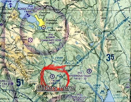
One surprise: Half-way between Clear Lake and Lake Baressa, encountered two sailplanes
in our flight path at almost the same altitude, 7,500. I was not expecting that.
My partner noticed a small field below us where the gliders where being towed
from,
it is the very small private field you marked on the SF chart. However, there
is
no
graphic
indication
to be alert for sailplanes. So be alert for sailplanes! (I've written to the
faa for chart emendation)
19 March 2004 22 March 2004 Scottsdale, Arizona to and back
Spring Training!
![]() KRHV -SNS - PRB - SLO - SMX - SBA -
GVO - CMA - WHP - SBD - BNG -
BLH - BXK - DVT - SDL
KRHV -SNS - PRB - SLO - SMX - SBA -
GVO - CMA - WHP - SBD - BNG -
BLH - BXK - DVT - SDL
Baseball! Spring training, I try to go down to see a weekend of Giants new
talent every year. For this year's trip decided to fly down ourselves. Long
trip over 3 major weather areas, in the middle of March, what the heck was
I thinking, a miracle would happen? Well heck, it did. Weather forecasts
were for clear flying all 700 miles of the route, clear and warm. Well, that
was the Friday weather, I still had to have faith in Monday for the return
trip.
Hour late getting to Reid, then another 1/2 hour trying to get some fueler
to come by an top us off. Chevron wouldn't answer, and Exxon was filling up
two prior calls. Needed the extra hour of fuel, guys! Finally fueled, got started.
At least the winds were dead calm so we took of from 13 instead of 31, gave
me back 3 minutes of the time I had lost by not having to do a crosswind and
base leg.
To give my partner some interesting scenery to look at I had planned down the
coastline and across the LA basin instead of down the Central Valley of California.
Taking the coast was only about 40 miles longer. First leg of the trip was
from Reid to Banning, on the east side of the LA basin, 350 some air miles.
Obviously (to me) this guy was just going to punch through the clouds under
positive coverage or not, and was trying to get the controller to tacitly approve.
Sheesh.
Down to the Camarillo VOR, then inland. Planned to cross the top of the LA
basin, LA TAC shows that to be the recommended VFR flyway over 5,000/6,500
ft. Very easy passage over LA, though it was nice to be getting traffic advisories.
Having traffic calls let me know ahead of time when a 737 out of Ontario crossed
my path within waving distance of the crew and pax.
3.5 hours into the flight, and near the desert. Planned fuel stop at Banning.
Banning is a very nice airport for being the edge of the desert. Very broad,
long runway. Somewhat weedy, and the taxiways are all-over weeds, but I spent
5 years at Edwards and taxing airplanes over tumbleweeds is fine.
Banning is difficult to see coming in from the west. Far side of town, and
all your looking for is a wide long lighter patch. Don't look for many buildings,
towers, or markings on the runway, just look past the small town and that pale
gray rectangle is the airfield.
Very nice gentleman came out to fuel us. Sat for 1/2 hour, smoked a pipe and
made sure we were all bathroomed-out before hopping back in.
Took off, into the desert. Picked up traffic advisories from Palm Springs approach,
did not want to cross the desert without someone watching
at least a little. Again, up to 9,500.
And drone drone drone. Pretty much a straight line to Blythe, then a dead straight
line from the Blythe VOR to the Buckeye VOR outside of Phoenix. 99 miles. Nothing
to see on the ground but dust and rocks. BTW, about 1/2 across the desert I
realized that we had stayed longer at Banning than I had planned, so I called
FSS and extended my flight plan by 1/2 hour. Next time I do this I'm not going
to do it in a Piper maxing out at 110 knots.
Whew, over that vast expanse o' nothing, into Phoenix. Luke approach picked
us up, dropped me down to 4,500. Of course, listened to Luke approach tell
someone (repeatedly) "No, you cannot get clearance to land at Luke. It's
a military base, official business only! No!". Could only hear one side
of the call, so don't know what the weasel was trying to do. Then over Deer
Valley and under the Class B (bout a 1,000 corridor) first call to Scottsdale
airfield.
Scottsdale handles a great many props and a great many corporate
jets, so the controllers have challenging sequencing jobs. The controller on
my initial call said "report 4 miles from the field (effective edge of
Class D), expect to orbit". OK. Called at 4 miles. The response, very
quickly "Expect
delays. Citation on final at 3 miles can you speed up. 024 turn immediate
left midfield downwind" so we were going in. go to the far edge of the
runways and tower asks "024 can you do a short approach?" Fine with
me "024 short approach affirmative" "024 clear to land 3" "024
clear to land". I turn in short, and the controller puts a Citation Pos & Hold
under me and tells the Citation on final to do S-turns. I land (a very nice
landing, I have to say), tower says very quickly "024 do not acknowledge
turn left at nearest taxiway Citation XXXX cleared for take off Citation
XXXX clear to land". Whew. I scooted off at A-5. Went to ground and asked
for transit parking. "Straight ahead" says ground. Sorry, I'm dense
today "Can you give me taxi instructions" "Straight ahead!".
OK, I start taxiing straight ahead. That's when the little golf cart from Corporate
Jets, the FBO for that side of the runway shows up in front of me with
a lineman to guide me to the parking spot. Very very thoughtful outfit (Lineman
even helped me push back!). My rental car was through Corporate Jets also,
and they drove out to the plane for me to take the car, so I could just unload
from the plane and into the car, no schlepping. 6.4 flight hours from RVH to
SDL.
Wine cellar looking a little empty. Sky looking perfect. Quick flight up to Sonoma
to visit some wineries. Some moderate turbulence about 5 miles south of Concord
airfield, more that usual.
Only real discussion point on the way up was my partner insisting that
the airfield I was descending into was not Sonoma. You can see runway 14
clearly, but she could not see the diverging 19, and swore it didn't match
the AOPA diagram so it wasn't right. So be prepared, if you're coming from
the southerly direction you may not be able to see the slant runway (though
I could)
Only other interesting thing was traffic pattern. My 3 airport references indicated
that usually I would be directed to left traffic to 14/19. When I was about 8
miles out I heard someone getting that guidance. Imagine my surprise when the
tower gave me "Report 3 miles on the right downwind for 14". Huh? Called to confirm "right
traffic" since he had just sent someone in on the left, AND because I was hearing
some occasional activity on 19, which would be right under right traffic for
14. Tower confirmed right, but asked me if I'd prefer left for 14. "No thank
you tower, right is fine, was just confirming". More laid back up here than in
San Jose, I guess.
Easy landing (long, wide runway) taxi to transit. Note: there are no facility
signs indicating where transit is. Look on a taxi map, download one from the
AOPA site. Rented car from Avis, drove around to 1,093,789 winery's so my partner
could taste wine.
Back to the airport, load 65 pounds of wine in the Piper luggage bay. Back up
and out, an easy hour back to RHV.
Quick flight, down to South County in a light rain, couple of landings, one go-round,
back to RHV
Reserved an airplane, hoping for a nice day. Nice Day. Took off at 10:30, flew
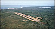
north around SF Bravo, turned coastward at Scaggs Island. 70 miles up the coast,
easy-to-spot Little river airfield. Windsock standing straight out perpendicular
to the filed, crosswind landing with a bump, but OK.
Shuttle to Mendocino is $5, picks you up from town at the top of the hour. Went
in to town for an hour (which, unless you're going to have lunch or dinner, is
about the right amount of time for Mendocino). Flew back to RHV.
Very clear, very smooth, all the way along. 
Weather:Ceiling unlimited ,20 miles vis, North winds 15-20
knots, 9c Duration:2.9 Landings: 2 Aircraft:PA28-181 N6413C
Had great hopes last night that the weather would break (been cloudy all week)
and it did! Got out to the airfield, line of clouds to the south but nothing north.
Good, since I had planned a flight north! Took off from Reid, headed to the SUNOL intersection, this flight
I planned to hit mostly navaids. Only challenge was the airplane's second
nav/comm was a big empty space (do the FAR require a inop sticker
over a hole in the panel? Hmmmmm), so I only had one VOR to use at a
time. Lots of switching back and forth. Hit
SUNOL about
1/2
mile
to
the
west,
not
too
bad.
Then visual
up to Buchanan airport (or concord, but the chart says Buchanan, dammit), turned
out towards Scaggs island. Flew straight inbound to the VOR, watching for traffic
out of Napa. Then northerly to BESSA, and intersection right off Lake Baryessa.
Up at 6,500 to keep clear of the mountains, next time I might pick 8,500 for
a little more padding.
Past BESSA, direct to the Williams VOR. Nice visual checkpoint is the town
of Arbuckle, easy to spot clump of buildings in the mids of lots of fields.
Had Colusa in sight at that time, descended for landing. By the way, and a
little complaining: Colusa and lots of other airports up her
in NorCal use 122.8 for CTAF. REMEMBER THAT!
Please don't be chatting on that frequency, there were so many stepped on transmissions
it was annoying. No-one at Colusa, greased a perfect landing with a 16 knot
wind right down runway 31.
Taxiing to the fuel tank, nice ole lady came out to turn the pump on and help me fuel. Also confirmed with her, it is pronounced Kooo-loose-a. Now you know.
If you're going north through the inland California valley I recommend this
as a fuel stop, very easy to see, easy to land, un crowded.
Taxied back to the active, making all the polite radio calls. Called taxiing
onto the active. Dammit a crop duster had already pulled onto the
runway at an intersection halfway up the runway and was taking off. Them guys
is nuts.
Back in the air and southbound. Climbed to 7.500 to pass over the mountains
with more buffer near Lake Baryessa. Height quandary, I'm between 178-183,
do I fly odd or even? Odd, and watch out. All nominal back to R-H, greased
another landing, even parked it in the spot straight.
Night currency flight. Reid-Hill was running reversed
runways tonight (13 instead of our usual 31), don't know why. No wind, guess
they just wanted to practice controlling folks backwards. Took off at 7:21,
straight out departure for South County (since we were reversed), up to 3,500
for the trip. Beautiful clear night. Down to SC, overflew, windsock was favoring
32 (not moving, but the last wisp of wind had pointed it that way) so I did
the normal right pattern 32. 3 landings at SC, none of which I'd like to
be evaluated on, please. That last 20 feet is so much harder to gauge at
night, I was a floater tonight. Took off again, wanted to fly some more,
flew south some more. Turned around, back to Reid. Only challenge on that
side of things is pattern entry for 13L at night, you're aimed at the hills
as you're dropping down to 1,100 ft, and the don't have many lighted features
to pick up. But fine. Current for another 90 days of passengers at night.
Two weeks of stinky weather, time to do a little something. Flight planned to King City(KKIC), backup plan to South County(Q99),
reality stay at Reid-Hillview. Very misty, could barely make out San Jose from the pattern at RHV. 8 TO/Landings. Two soft fields, my least proficient takeoff. First soft field was, urrrr, kinda a regular takeoff, skimming the runway at 300 feet doesn't
really make a soft field. Tried again, second attempt was very nice. 7 landings just great, one was a little bit of a floater.
7
Weather:Ceiling 20,000 clear, calm.Cold,
-5 at 5,500 Duration:.2,2 Landings: 2 Aircraft:PA28-181
N6413C
Been a few weeks, time to fly. Chose to take a round-robin
of the inland valley south of Sacramento, give my partner her first look
at the area from the air, take a look at the snow on the Sierras, and cruise
around building X-country time.
Get to the airport, out to the airplane. Dammit what's this junk? Frost on the danged airplane windshield????? I thought we paid such high taxes here in California to keep way from this frost stuff???? Scrape scrape.
Took off at 1030 pst, climb out over Calaveris Res, headed for Livermore. Weather
on DUATS had given synopses for all of CA as VFR, but when I called Oakland
Radio to open my flight plan the ATC tech said It's been IFR in the inland
valley, but satcom shows nothing now. What? I guess it was IFR sometime
in November, too, but don't care right now. Thanked him anyway. 40 minutes
out to Oakdale for the mandatory 1st bio break, clear and smooth all the
way.
Oakdale The incredible disappearing airport. I had the airport
in sight 10 miles out, and circled to lose 2,000 ft. Why so much altitude?
Well, I didn't have a good TOD checkpoint, so I started my decent when I saw
the airport 6 miles ahead. Also dang the cold air makes the airplane
go good, I was clipping along at 128 knots groundspeed.
And dammit if Oakdale
didn't disappear. This has happened to me before here, I don't know what it
is. The dark black runway really stands out, but I lose it anyway. Circled
again, picked it up again. OK landing, little hop. I don't much like Oakdale's
runway, it has a significant hump in the middle that throws me off. Taxied
to get fuel and something warm to drink for my partner (she was getting chilly).
Two FBOs in the middle closed, dang it. Started up again and taxied to the
self-service pump (large white tank at the far end of the ramp area, near the
28 runup). Put in 8 gallons, fuel calcs seem right.
Taxi on to 28.
Looked at that stupid hump in the middle of the runway and decided to do a short
field, got the wheels up right before the crest of the hump.
TUrned almost due south, flying down to Los Banos. Flight plan open, FSS
would love Pireps, well yeah, I'd love to give you one but the weather
reports seem to be identical to reality, so you got it right.
Overflew Los Banos without landing, my partner wants to keep it in the air, needs
to be in Santa Cruz at about 2:30. Turned West, climbed up to 6,500 to cross
the hills. Over Fraser Lake turned north and began to slowly descend.Beautiful
landing at Reid-Hillview.
Weather:Ceiling 15,000 clear, calm. Duration:.1.1 Landings: 2 Aircraft:PA28-181
N6413C
100th anniversary of powered flight. Skipped the first 2 hours of work and had my own commemorative flight, out to Watsonville and back.
Weather:Ceiling 8,000 broken, calm. Duration:.1.9 Landings: 2 Aircraft:PA28-181
N4313G
Wanted to fly up to Mendicino. Nope, clouds and rain. Santa Maria? Nope, clouds and rain. OK, flew down to King City. Nothing to report.
Weather:Ceiling 17,000 scattered, calm. Duration:.1.3 Landings: 3 Aircraft:PA28-181
N26024
Haven't flown in a bit. Flew down to South County (Q99) did a couple of landings. Did some steep turns. Back to Reid.
Weather:Ceiling 12,000 scattered,
calm. Duration:.1.0 Landings: 2 Aircraft:Cirrus
SR-22
OK, so yeah, I wanna buy an airplane. And maybe I want to take out a house-sized mortgage and buy a new Cirrus. Or not. But I sure do want to fly one to be sure I'm interested.
I'm interested
If you have a chance, test-fly one of these. Of course, if you test-fly one,
you'll want to buy it. Flew an hour out of Reid, one landing at Hollister. Very
fast, very precise handling machine. Push the side stick to where you want the
airplane, it goes there and stays. Clips along at 155 knots at 74%, the all-glass
display showing you not just your standard instruments, but the direction and
speed of the wind you're flying in. Engine leaning means flip over to a huge
graphic display that makes it dead simple and accurate. The TCAS system, audibly
announcing traffic, I found less than useful, though. In our environment around
RHV there are lots of planes around, and the TCAS warnings tended to step on
each other with multiple spottings, and you might be looking at what you think
it's taking about when in fact there is an airplane closer in and more of a factor
for you.
Another real quirk of the Cirrus when you first fly one is the perceived angle
of attack. You have a much greater view downward in the Cirrus than most other
aircraft, the front windshield lets you see much more below eye level than you're
used to. What this translates into is over-pitching on climb, and definite nose-too-high
on landing.
When I took it in to Hollister and let the sales pilot fly the last bit of the landing it really really felt like we were going to land on the nose wheel. But no, just happens that I can see more down, so it feels like the nose is at a steeper angle, isn't.
Back to Reid. Maybe I'll buy one.
Weather:Ceiling 6,000, clear under thick ceiling, calm. Duration:.2.3 Landings: 2 Aircraft:PA28-181
N26024
Route:RHV - KLVK - Q53 - O61
Flew up to Cameron Park airpark to see family.
Cameron Park is an airfield serving a community with taxi-wide
streets and hangars attached to every house, I always wanted to go up there,
see if it might be a place we would want to retire at. One of Karen's cousins
lives nearby.
The weather was overcast all day, with reports of lower ceilings and rain
moving in from the north late in the afternoon. But a 4,500 and 5,500 altitude
flight looked good when we got to the airport at 10, so we decided to try.
Made it very clear that we'd turn around if anything got bad.
The outbound flight was seamless. The thick cloud layer held steady at
about 6,400 ft, so we were well under it in very smooth air all the way
along. The
only comment I have is about one of the checkpoints, Franklin. Some
may say this airfield exists, I ain't seen it. We looked hard, too. Navigation
said we were near it. GPS said we were right over it. Damned if I could see
it, either on the outbound or inbound flight. Fortunately there are some transmission
towers right nearby where Franklin should be, easy to see (be high to avoid
them), and Mather airfield can also be seen. Straight on to Cameron Park, which
is easy to see.
Cameron Park is a quirky airfield. It is in a valley bowl, which means a few
things. First, there are hills with houses at either end of the airstrip. Second,
the threshold of 31 is displaced about 1,000 feet. Third, the airstrip dips
in the middle, so you're landing downhill/taking off uphill for some portion.
I had read about all this before flying in, and was a little concerned. But the actual landing was really simple.
Landing on 31, you aim at the runway side of the hill, and turn a nice final
right over the hill, descending along the slope of the hill. You're a little
steeper than usual, and that allows you to aim at the arrows on the displacement,
then right on down. I did not notice the runway dip on landing.
Transit parking is tiny, space for 4 airplanes packed tight, and it looked like the other 3 were permanent, not transit. They are working on expanding the asphalt.
And once again, I'm supposed to pay somebody for transit parking, but can't find
a soul. Get picked up by relatives, have lunch. All the while worrying about
whether the clouds are getting lower or not . Ended up staying just an hour and
a half, I really didn't want to get socked in.
Takeoff was more affected by the runway than landing. I taxied to the end of
31, looked at the dip, and said "Lets get off the ground fast", so a Vx takeoff
was in order. 25 degrees of flaps, full power, brake release. Off the runway
well, but dang the hill at the end of the runway approaches fast. Flew over it
with at least 400 ft. to spare, but you really want to take off short field at
this place.
Solid overcast (the ceiling had not dropped) again all the way home, nice and smooth.
Weather:Ceiling 7,000, some fog, calm. Duration:.3.0 Landings: 2 Aircraft:PA28-181
N26024
Route:RHV - RANCK - Soledad - KKIC - KPRB
My partner really likes Justin wine, and this weekend is their annual party, also the chance to pick up your Justin Reserve wine for the year.
Excellent opportunity for our first
cross-country together.
Planned the flight, intended to go from the Silicon Valley over to Salinas airport,
then follow 101 south. Checked the Notams. Oops! Air show at Salinas, TFR!
No traffic below 15,000. OK, what else? Decided on the VOR intersection RANCK,
this would position us well for a westbound turn out to 101.
Took the Garmin 196 along for Karen to be assistant navigator with (in other words, hold the thing and point the screen at me when I ask hehehe).
Normal takeoff and climbout. Down south to Frasier Lake, then dial in the VORs for RANCK.
Hmmmmmm. Fog and mist ahead, wasn't in the weather briefing because it's in this inland valley. How's our vis? Starting to get smaller, probably 7 miles, roughly 5 miles from the nav fix.
Look right. Yes, I can see Soledad and Hwy 101 already, turned west before hitting RANCK.
Down the valley, next fix King City. Or as I like to call it, the airport
that's closer than I think. Every time I fly down by KKIC I am surprised when
it's 3 miles in front of me, not 7.
On to Paso Robles.
Paso Robles shows up right where it should be (be careful of the restricted area to the west when coming down from the north). Very very visible, the transition from low rolling hills
to the flatlands that a large airport can sit on makes finding KPRB very easy. Gee Whiz, runway 1 is 6,000 feet long! I can land 3 times! No traffic, land and taxi forever to transit.
Park, tie it down, then go to the FBO on the south side of the terminal.
Enterprise rental car dropped a car off for me there (easy! just call, they're
used to it). No-one in the FBO, except the cat which I gave the proper worship
to. Looked on the desk, there's my contract and keys. Signed and initialed
what I figured was the right number of places, then went out to the car.
Went to Justin, but that's not a flying story so I'll leave that out (except
to say no, I didn't even taste any wine, I'm not silly).
Paso Robles is a very nice field, and they have a very nice, brand new,
multi-million dollar terminal.But Why? They have minimal, short hop only,
commercial flights. Nice pilots lounge, phones, pretty good overall BTW,
the references say their is a transit fee if you park longer than 3 hours.
Well spank me for a loser, I'd love to help you people out but I couldn't for
the
life of me figure out who to pay. Happy to do so, but can't pay who you don't
see.
Back to the airport about 3:30. Drove the rental car out to the airplane
because we had 35 pounds (yes, I weighed it and re-WB'd) of wine to put in
the baggage compartment, bungee all the wine boxes down. Get in, file a flight
plan 1-800-WX-BRIEF.
Weather:Clear and calm. Duration:.8 Landings: 6
night Aircraft:PA28-181 N26024
Not current on nights. Don't want to fly x-country with a passenger without being night current, so went out and did my night landing thing. Very very nice night, the airplane really wanted to fly, hard not to just exit the pattern
and go flying. But I was hungry, so landed and went to eat.
Weather: Clear and calm, unlimited ceiling. Duration: 1.3 Landings: 2 Aircraft:PA28-181
N4313G
Karen Familiarization Flight. My first flight as a private, took my partner
Karen up for a quick flight to get her back into a small airplane cockpit.
She flew with her father in his Baron as a child, so there wasn't any trepidation.
Just thought it was a good idea to go for a short flight and through some maneuvers
to get her used to me at the controls. Also, since she's going to be my second
pair of eyes and part time navigator, wanted to practice identifying airports
and other landmarks from the air.
Normal takeoff from RHV, downwind departure. Flew 120 down to Fraiser Lake at 5,500. I like using Fraiser Lake as a VFR checkpoint,
the long water strip (it's a seaplane training strip) is very easy to see from the air. Turned west, up to 6,500 over the mountains, and over to Watsonville.
Watsonville is a superior airport for training, or for taking someone who's a little uneasy into a very smooth landing. Occasionally obscured by ocean fog.
Runway 20, the calm wind runway,
is 4,500 feet long by 150 wide, so you have to be making huge mistakes to scare
your passenger. Also has a nice taxi-up Mexican restaurant on the field.
One other airplane in the pattern, spiraled down to TPA and nice easy landing.
Karen's' only concern was seeing the runway on base. Left pattern, so when
we were down to 700 ft. MSL she was looking ahead at nothing but trees and
didn't know where the runway was. Taxied back to 20, took off. Eastbound aimed
at Hollister. Waited until
she was able to identify Hollister from the air, then back up to RHV for a
nice landing.